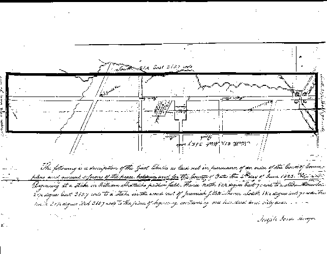
The Gaol Liberties Map of 1825
The map shown below is a much-reduced copy of the earliest one known of the not-yet- incorporated village. It was made in 1823 to show the "gaol liberties" as part of Penn Yan's new designation as county seat. These were the boundaries within which people imprisoned for debt could work (and hence pay off their creditors) and still be considered within the limits of the jail. A more detailed map was made a couple of years later, with much enlarged boundaries. The originals of both maps are in the County's archives.
Main Street runs nearly north and south, from left to right across the middle of the map. On the right are shown the four mills at the south end of Main Street, the two on the south bank labeled Jilletts Mills, since they belonged at that time to Jeremiah Jillett; and the other two on the north bank labeled Wagener's Mills, as they belonged to Abraham Wagener.
In the center of the map is the Public Square, site of the courthouse and jail built a year later in 1824. Ira Gould's store is at the corner of Main Street and Head Street, towards the left. Main Street continues on north; just off this map it makes a slight kink to the west and eventually finds Benton Center in the middle of the town of Benton.
The boundaries of the Gaol Liberties are shown as a dark rectangle. Running along the western boundary near the bottom of the map is the road called here Back Street, renamed Church Street by 1825 and now Liberty Street, probably so named in 1826 (the semicentennial of the Declaration of Independence). The road leading east (up) from the foot of Main Street is now Seneca Street; it was in 1825 called Cooper Street, and later Canal Street. The road leading west (down) from Ellsworth's store is now Elm Street; roads also going west across Back Street include streets about where Chapel and Court Streets now lie, though a third one north of Court Street no longer exists; its extension to the east is now a one-way alley called Mill Street and once went down to a fulling mill on Jacob's Brook owned by Morris F. Sheppard.
The map shows three house lots north of the Public Square. Two of them give the names of the owners, A. Holden and G. F. Betts; in between them is the "Center Stake" marking the halfway point between the north and south extremes of the Gaol Liberties.
The Outlet of Keuka (then Crooked) Lake is at the south (right) end of Main Street, where the mills are. The milldam formed a pond, quite narrow here but swelling farther east off the map. The only other natural feature shown is Jacob's Brook, flowing down from Benton and joining the Outlet near Abraham Wagener's gristmill. A year after this map was made, in 1824, this building burned to the ground and was rebuilt as the structure now housing Birketts Mill.